Tag Archives: Lake Michigan
Late October color at Promontory Point
ChocolaTea, Portage, Warren Dunes State Park
October 20, 2024
I’d first discovered ChocolaTea in Portage, Michigan, when I’d spotted their giant teacup being hauled down a road running parallel to the my Amtrak Wolverine train. I’d been so curious about it I’d emailed ChocolaTea, and they’d sent me photos, including this one.

J had taken me there in 2013, and he wanted to return. I’d seen on social media the tornado that had ripped through Portage earlier this year had missed ChocolaTea (but not by much).
Off we went on another beautiful day. On reaching Michigan, we had to stop at the Michigan welcome center. It’s worth it for the faux lighthouse and historical markers (not to mention snacks and the necessary). There’s also a wealth of Michigan tourist publications. I had to restrain myself to just a few.
After arriving in Portage, we spotted a Tim Horton’s. Woohoo! The main part was closed due to a staffing shortage. but the drive-through was open. I wanted to stop there on the way out.
ChocolaTea at last! It’s in a small shopping center, so at first there wasn’t a parking spot available. I went in while J looked for one, found a seat, and looked at the menu — I’d forgotten ChocolaTea serves some food. By now I was hungry.
I did look around some after a light lunch and picked up more of the brownies I’d liked so much before — they still had the same kind after all these years. Thanks to my all-around poor condition, I couldn’t look around nearly as much as I wanted to — just as well, perhaps, for my girth.
We ate inside, but got drinks and headed outside — it was that pleasant a late October day. ChocolaTea is at the end of the shopping center and has a deck overlooking Portage Creek. If it weren’t for the traffic noise, it would be a very pleasant spot. I didn’t want to leave.
Leave we must to make it back at a reasonable hour — but first we made a few stops. Portage has several parks and nature preserves, so we briefly checked out a couple. Well, I checked out the lake at one, and J also explored the trail at another. I thought about looking for the path of the tornado, but decided against it.
After the promised visit to Tim Horton’s, we set off with the idea of stopping at Warren Dunes State Park, which would close at sunset. The sun was already low, so time to make tracks! We got there just in time to enjoy a few beach moments.
Then as always all good things must come to an end . . .
Markers (partial text):
NEW BUFFALO WELCOME CENTER
The nation’s first Highway Travel Information Center opened on May 4, 1935, on US-12 at New Buffalo, not far from here. Other states followed Michigan’s lead, and by 1985 there were 25l travel information centers across the nation. The New Buffalo center was built by the Michigan State Highway Department, now the Michigan Department of Transportation, to welcome motorists entering the state via US-12. It was relocated at this site, with its more modern building, on April 6, 1972. after the I-94 Freeway was completed. Michigan’s state-wide travel information program, which began in 1935, includes staffed welcome centers and interpretive, promotional and informational displays at rest areas and roadside parks across the state.
BUREAU OF HISTORY, MICHIGAN DEPARTMENT OF STATE
REGISTERED LOCAL SITE No. 1256
PROPERTY OF THE STATE OF MICHIGAN
1986
EISENHOWER INTERSTATE SYSTEM
During the presidency (1958-1961) of Dwight D. Eisenhower, the 34th President of the United States, the National System of Interstate and Defense highways was finalized and signed into law. Gaining support for the Interstate Highway System required foresight and courage by President Eisenhower as he committed the Nation to an intensive program of road building.
THE IRON BRIGADE
The Iron Brigade became one of the most celebrated military units of the American Civil War (1861-1865). Wearing distinctive black hats, they were easily recognized by friend and foe alike. The five volunteer regiments in the brigade were the 2nd, 6th and 7th Wisconsin, the 19th Indiana and the 24th Michigan. These regiments ranked among the most gallant and effective of the Union Army. U.S. 12, which intersects nearby, is named the Iron Brigade Memorial Highway in their honor.
HONOR THE DEAD BY HELPING THE LIVING
DEDICATED TO THE MICHIGAN MEN AND WOMEN WHO GAVE THEIR LIVES FOR THEIR COUNTRY.
1776 1976VETERANS, OF FOREIGN WARS AND LADIES AUXILIARIES
DEPARTMENT OF MICHIGAN
MAY 4 1976
In Michigan, we’ll leave a lighthouse on for you. Over 100 historic lighthouses grace our shorelines — more than any state in the nation. Just as these magnificent beacons helped ships navigate through our lakes, look for this lighthouse to guide you and your family on your travels throughout our Great Lake State.
Sunset before invisible Perseids at Indiana Dunes State Park
August 10, 2024
The Perseids never became visible thanks to cloud cover that moved in with the evening, but at least sunset gave off a nice glow and showed off the downtown Chicago skyline.
Fog blowing west from Lake Michigan into downtown Chicago
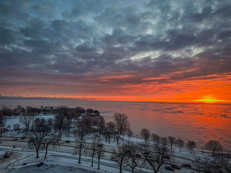
Rare visible winter sunrise over Lake Michigan
During most of the winter in Chicago, the sky is a uniform leaden gray. Today, however, there was a moment of sunrise with some defined clouds. Right under the sunrise are the steel mills of Indiana with their plumes. During summer, the sun will rise over the Chicago Park District field house to your left.

Third day of sea smoke on Lake Michigan
January sea smoke on Lake Michigan at -7°F
January sea smoke on Lake Michigan at -9°F
More January sea smoke on Lake Michigan. See this article by Catherine Schmitt for the science behind sea smoke.


